


US Topo Maps
Description of US Topo Maps
USA-এর জন্য সেরা উপলব্ধ মানচিত্র এবং বায়বীয় চিত্রগুলিতে বিনামূল্যে অ্যাক্সেস সহ আউটডোর নেভিগেশন অ্যাপ ব্যবহার করা সহজ।
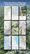
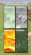
নিখুঁত ভ্রমণের পরিকল্পনা করতে 30+ মানচিত্র স্তরগুলির মধ্যে (টোপোস, এরিয়াল, সমুদ্রের চার্ট, ...) বেছে নিন
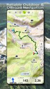
ব্যাককন্ট্রিতে অফলাইন ভ্রমণের জন্য আপনার অ্যান্ডয়েড ফোন/ট্যাবলেটকে একটি আউটডোর জিপিএসে পরিণত করুন।
অন্যান্য উত্স থেকে সহজেই মানচিত্র যোগ করুন (GeoPDF, GeoTiff, WMS এর মতো অনলাইন মানচিত্র পরিষেবা, ...)
মার্কিন যুক্তরাষ্ট্রের জন্য উপলব্ধ বেসম্যাপ স্তর:
• USGS জাতীয় মানচিত্র Topo
• ইউএসজিএস জাতীয় মানচিত্র চিত্র টোপো
• USGS জাতীয় মানচিত্র চিত্র
• USGS NAIP HiRes চিত্রাবলী
• USGS Topo ঐতিহ্যগত DRGs: USA-এর টোপো মানচিত্রের সীমাহীন কভারেজ 1:250.000, 1:100.000, 1:63.000 এবং 1:24.000/25.000 এ
• FSTopo বন মানচিত্র
• NOAA নটিক্যাল RNC চার্ট
• জাতীয় উচ্চতার মানচিত্র (পাহাড়ের ছায়া, ঢাল মানচিত্র, আকৃতির মানচিত্র)
বিশ্বব্যাপী বেসম্যাপ স্তর:
• OpenStreetMaps (5টি ভিন্ন মানচিত্র লেআউট), স্থান সংরক্ষণ ভেক্টর ফরম্যাটেও ডাউনলোডযোগ্য
• Google মানচিত্র (স্যাটেলাইট ছবি, রাস্তা- এবং ভূখণ্ড-ম্যাপ)
• বিং ম্যাপ (স্যাটেলাইট ইমেজ, রোড-ম্যাপ)
• রাতে পৃথিবী
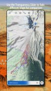
একটি ওভারলে হিসাবে একটি বেসম্যাপ স্তর কনফিগার করুন এবং একে অপরের সাথে মানচিত্র তুলনা করার জন্য একটি স্বচ্ছতা ফ্যাডার ব্যবহার করুন।
অন্যান্য উত্স থেকে মানচিত্র যোগ করুন:
• জিওপিডিএফ, জিওটিফ, এমবিটাইলস বা ওজিতে রাস্টার মানচিত্র আমদানি করুন (Oziexplorer OZF2 এবং OZF3)
• WMS বা WMTS/Tileserver হিসাবে ওয়েব ম্যাপিং পরিষেবা যোগ করুন
• ভেক্টর ফরম্যাটে OpenStreetMaps আমদানি করুন, যেমন মাত্র কিছু GB-এর জন্য সম্পূর্ণ USA
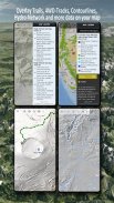
উপলব্ধ মার্কিন মানচিত্র ওভারলে - অন্য কোনো ভিত্তি মানচিত্রে অতিরিক্ত তথ্য যোগ করুন:
• সরকারি জমির মালিকানা (PAD-US 3)
• জাতীয় হাইড্রোগ্রাফিক ডেটাসেট
• মোটরযান ব্যবহারের মানচিত্র (USDA)
• এলিভেশন কনট্যুরলাইন
• 4WD ট্রেইল
• পথচলা
• রাস্তা, রেলপথ, বিমানবন্দর
বিশ্বব্যাপী ওভারলে উপলব্ধ:
• হিলশেডিং ওভারলে
• 20 মি কনট্যুরলাইন
• OpenSeaMap
কোন নিখুঁত মানচিত্র নেই. বিভিন্ন মানচিত্রের স্তরগুলির মধ্যে টগল করুন বা সবচেয়ে আকর্ষণীয় রুট খুঁজে পেতে মানচিত্র তুলনা বৈশিষ্ট্য ব্যবহার করুন৷ বিশেষ করে পুরানো ঐতিহ্যবাহী ডিআরজিতে অনেক ছোট পথ বা অন্যান্য বৈশিষ্ট্য রয়েছে যা আধুনিক মানচিত্রে অনুপস্থিত।
বহিরঙ্গন-নেভিগেশন জন্য প্রধান বৈশিষ্ট্য:
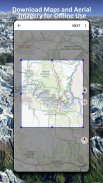
• অফলাইন ব্যবহারের জন্য মানচিত্র ডেটা ডাউনলোড করুন৷
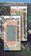
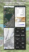
• পথ এবং ক্ষেত্র পরিমাপ করুন
• ওয়েপয়েন্ট তৈরি এবং সম্পাদনা করুন
• GoTo-ওয়েপয়েন্ট-নেভিগেশন
• রুট তৈরি এবং সম্পাদনা করুন
• রুট-নেভিগেশন (পয়েন্ট-টু-পয়েন্ট নেভিগেশন)
• ট্র্যাক রেকর্ডিং (গতি, উচ্চতা এবং নির্ভুলতা প্রোফাইল সহ)
• ওডোমিটার, গড় গতি, বিয়ারিং, উচ্চতা ইত্যাদির জন্য ক্ষেত্র সহ ট্রিপমাস্টার।
• GPX/KML/KMZ আমদানি/রপ্তানি
• অনুসন্ধান (স্থানের নাম, POI, রাস্তা)
• উচ্চতা এবং দূরত্ব পান
• মানচিত্র দৃশ্য এবং ট্রিপমাস্টারে কাস্টমাইজযোগ্য ডেটাফিল্ড (যেমন গতি, দূরত্ব, কম্পাস, ...)
• ওয়েপয়েন্ট, ট্র্যাক বা রুট শেয়ার করুন (ইমেল, ড্রপবক্স, হোয়াটসঅ্যাপ, .. এর মাধ্যমে)
• WGS84, UTM বা MGRS/USNG (মিলিটারি গ্রিড/ US ন্যাশনাল গ্রিড) এ স্থানাঙ্ক ব্যবহার করুন,
• ট্র্যাক রিপ্লে
• এবং আরো অনেক ...
হাইকিং, বাইকিং, ক্যাম্পিং, ক্লাইম্বিং, রাইডিং, স্কিইং, ক্যানোয়িং, হান্টিং, স্নোমোবাইল ট্যুর, অফরোড 4WD ট্যুর বা সার্চ অ্যান্ড রেসকিউ (SAR) এর মতো বহিরঙ্গন কার্যকলাপের জন্য এই নেভিগেশন অ্যাপটি ব্যবহার করুন।
দ্রাঘিমাংশ/অক্ষাংশ, UTM বা MGRS/USNG ফর্ম্যাটে WGS84 ডেটাম সহ কাস্টম ওয়েপয়েন্ট যোগ করুন।
জিপিএক্স বা গুগল আর্থ KML/KMZ ফর্ম্যাটে জিপিএস-ওয়েপয়েন্ট/ট্র্যাক/রুট আমদানি/রপ্তানি/শেয়ার করুন।
বৃষ্টি কখন শুরু হবে/থেমে যাবে তা সঠিক ভবিষ্যদ্বাণী করতে অ্যানিমেটেড NEXRAD রেইন রাডার দেখুন
অনুগ্রহ করে support@atlogis.com এ প্রশ্ন, মন্তব্য এবং বৈশিষ্ট্যের অনুরোধ পাঠান
US Topo Maps - APK Information
APK Version: 7.7.2Package: com.atlogis.northamerica.freeLatest Version of US Topo Maps
Other versions


Apps in the same category


